TRANSLATE, TRADUIRE, ÜBERSETZEN, TRADUCIR, 翻译

Sunday, October 28, 2012

Sagalassos -- first stop on our 6-day tour

Friday, 19 October 2012
As always, click on any image for larger view.

Last summer we signed up for an October group tour to Cappadocia; a small group tour.  This tour was arranged by Gwen in Marmaris.  Gwen is an American woman who has lived in Marmaris about 10 years in Netsel Marina aboard her yacht called K.W.  Gwen arranges many tours to lots of destinations in Turkey, and her tours are quite popular with cruisers.  She is not a travel agent and has no financial gain in these tours.  She does it to benefit the cruising community, for which we owe her a great big "thanks!".  

The small bus for our tour held 14 passengers, leaving 1 vacant seat on the back row that allowed a bit of stretching room for the folks seated back there.  As per our guide's suggestion, everyone switched seats daily to allow everyone a time in the 'best' seats.  Eight people were on boats docked at Yat Marine in Marmaris and that is where the tour originated.  Lucky us; Fethiye is on the way to Cappadocia.  The little bus collected another couple whose boat is docked at the large ECE Saray Marina (next door to us), then picked us up at the front door of Yacht Classic Hotel.  What could be more convenient for us!  Our guide was a very nice, friendly and well-educated young man nicknamed Tas; I never got his real name.  His command of the English language was excellent, both British version and American style.  Tas is very well-traveled both in Europe and America and is a licensed national guide in Turkey.  We would recommend this tour company and would definitely recommend Tas as a guide.  Here is a link to the 6-day tour we enjoyed: Koral Tourism and Travel Agency  

Please note that this tour does require a certain level of physical agility and endurance.  There is a lot of walking up and down and lots of steps or stairs to negotiate at the various sites visited.   Walking on uneven stones is tough on the joints and can be a tad painful for some of us older folks.  Glad we went now because I don't think I will be physically capable of doing this tour in another 5 years.  Just sitting in the bus for approximately 2600 km (1560 miles) over 6 days was taxing enough for old people with arthritic hips and knees.  The tour does make comfort stops every 2 to 2 1/2 hours and it does help greatly to walk around for a few minutes.
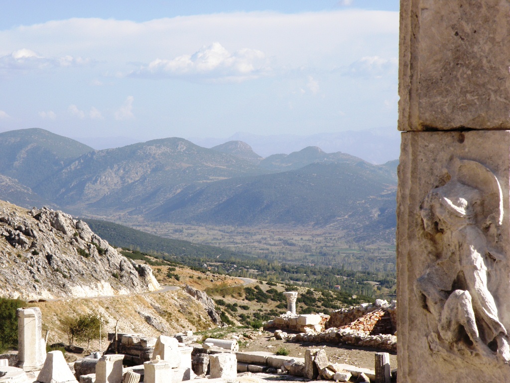
Looking across valley from Sagalassos


Our first stop was 4 hours away in the Lake District -- the archaeological dig site of Sagalassos, known most appropriately as The City of the Clouds.  Tas explained that the pronunciation of the name literally translates in local dialect to 'Make Him Cry.'   I think City of the Clouds sounds better.


Another view from Sagalassos


The ancient city of Sagalassos truly was a city of the clouds.  It is situated near the top of a mountain and affords lovely views.   The ancient city sprawled in terraced fashion near the top of Ak Dag (White Mountain) from altitudes of 1450 meters to 1700 meters (5525 feet), backed by steep rock face to the mountain top.   Sagalassos is surrounded by mountain tops on 3 sides and affords splendid views of the valley below on the single open side.  


Bill at Sagalassos, way up high


During Roman Empire times this city was known as the "first city of Pisidia" and the region was first called the Province of Asia and later called the Province of Galatia.  Today this region of the Taurus Mountains is known as the Lake District.  Human settlement of the area goes back 8,000 years, long before the Romans arrived.   Although settlement is confirmed to be be pre-Hellenistic, all the surviving ruins being refurbished are of Roman origin.


Another Hadrian arch?


Alexander the Great conquered Sagalassos in 333 B.C. on his way to Persia.  The city had a population of only a few thousand at that time and was one of the wealthiest cities in the region. 


Note wooden steps on right going uphill


Several centuries later, under Roman rule, Sagalassos (or Pisidia as they called it) was particularly favored by the Emperor Hadrian.  He declared it "first city" and the center of Galatia province.  A very large statue of Hadrian has been unearthed in Sagalassos.  Another very large statue discovered there is believed to be of his wife Sabrina.


Ancient Roman tiles being used as support for new path.
Wonder if the archaeologist know this is being done
by the construction workers building this path.

After Roman rule the city fell under control of various rules as different peoples gained and lost control of the region

Around 400 A.D. the city was fortified for defense.  In 518 A.D. an earthquake devastated the city.  Around 541 a plague halved the local population.  In 640 a massive earthquake destroyed the town and the inhabitants abandoned Sagalassos and resettled in the valley nearby.   Sagalassos disappeared from records at this time.


Such detail in the stonework

The site remained virtually ignored from 640 until explorer Paul Lucas, who was traveling in Turkey on a mission for King Louis XIV of France, visited here in 1706.   During those intervening 1066 years erosion had covered the ruins of Sagalassos.  The city had not been looted to any significant extent because of its location.  After Lucas' visit, the site remained vacant and unmolested.   In 1824 a British chaplain at Izmir visited the site and deciphered its name in inscriptions.  Western travelers began to visit the ruins occasionally; however, the city did not attract much archaeological attention until active excavation  of this site began around 1985 by a Belgian-British team.  That work continues today.  This should be a spectacular site when all the work is completed, easily rivaling Ephesus as a tourist destination.  This is the largest archaeological project in the Mediterranean region.   BTW, it is possible to arrange a wedding in this unique setting.  That would be really special but getting the wedding guests to this somewhat remote location might be challenging.
Looking down on the lower level agora (shopping area)
and a wide pedestrian street area


Rather than write a lot of detail about what we saw and learned, here is a link to what I consider the best website for this site:
Sagalassos archaeological site

Dig around on this site for lots of information if so inclined.


If you have Google Earth, this link to an interactive map of Sagalassos archaeological dig is interesting:
Interactive map of Sagalassos (using Google Earth)


Roman Baths -- what a view they had!


We exited the bus at the level of the old Roman baths and Tas explained about those.  I won't relate any of that info because I have previously written about many of the Roman baths we have visited and they are all about the same.


More of the Roman Baths


Antonine Nymphaeum at Sagalassos
Gravel on floor in front covers mosaics to protect from sun

Next we walked many steps up to the Antonine Nymphaeum and upper Agora (shopping district).  By the time we got up there I was huffing and puffing due to the elevation and exertion and decided to skip going farther uphill to the theater.  Fellow tour participants who opted to visit the theater said it was like all the other theaters we have visited.  I think the capacity for this theater was around 9,000 persons, so it was not one of the larger theaters of ancient times.


Roman theater at upper level of Sagalassos


Between the nymphaeum and the theater are the pre-Hellenistic Doric Fountainhouse and the Roman Neon Library.  The library supposedly has an exceptionally fine mosaic floor, but it is kept locked.  According to our Lonely Planet guidebook, visitors can ask at the ticket booth and they will loan a key; but we did not read the book until later and missed this opportunity.


How the nymphaeum originally looked, upper level.
Water ran through channels down to the lower level
to a collection pool beneath that circular roof.

While they continued to the theater Bill and I explored the Bouleterion and Heroon (hero's monument--it is believed a large statue of Alexander the Great once stood here)  which were nearby the nymphaeum.  There were few signs in place to explain what we were looking at.  Looking downward on the mountainside we could see the larger lower-level agora (shopping district) and the macellon (food market area) with their trademark Corinithian columns.  In the middle of the macellon was a large thoios (a deep fountain where live fish were stored and sold).  This macellon was dedicated to Emperor Marcus Aurelius. 

Another view of the Antonine Nymphaeum


The nymphaeum has been restored nicely.  Water flows and fills the fountain just as it did during ancient years.  The piping has been reattached to the original source used over 2,000 years ago.  The statues were largely destroyed by earthquakes over the centuries.  Replicas now stand in their places.  The link above provides additional links to information on the huge statues already unearthed at this site.   One was a 16-foot statue of Emperor Hadrian.


Bill at nymphaeum.  Note water pouring from the
2,000 year old source


The link also shows some of the mosaic floors found at Sagalassos.  The photo shows a design we have never see before.  Unfortunately for us, the mosaics have been covered with a thick layer of sand and gravel to protect the tiles from farther UV damage.  So we were unable to see them.


Bill sitting on the stone trim that encircled the structure
 where statues stood in the square in front of nymphaeum

While reading about Sagalassos I found this interesting tidbit on Wikipedia:
"In a phylogenetic study the mitochondrial DNA of 85 skeletons from Sagalassos dated to the 11th–13th century AD was compared to modern populations. The research found a significant maternal genetic signature of Balkan/Greek populations, as well as ancient Persians and populations from the Italian peninsula. Some contribution from the Levant was also detected, whereas no contribution from Central Asian population was ascertained."


In this short video of Sagalassos I mentioned Marcus Antonius (Marc Antony) because that is what I understood the guide to say.  That was in error.  Should have been Marcus Aurelius.  Sorry about the scratchy audio.  Nothing I can do about it.


After exploring the City of the Clouds we were supposed to stop in Isparta for bazaar and to learn about the largest local business of rose oil production, but our group voted to skip it.   We were all tired from the long drive and our mountaintop exploration of the archaeological site.  Another hour's drive delivered us to the small mountaintop town of Egirdir where we checked into the Altingol hotel.   Hotel Altingol on Lake Egirdir   
Lake view from our hotel room upon afternoon arrival

Almost directly across the street from the hotel was the Hizir Bey Camil which was built in 1237 and served as a Seljuk warehouse.  It was turned into a mosque in 1308 by the emir Hizir Bey and remains in use today.  Opposite the mosque stands the Dundar Bey Medressesi, a madrassa (university) built in 1218 A.D. by the Seljuk sultun Alaeddin Keykubat.  It was originally built to be a caravanserai -- a place where trade caravans stopped for the night.  (The roads today follow the paths of the ancient camel trade caravans.)   In 1285 the caravanserai was converted to a madrassa.   Today the madrassa houses a bazaar supposedly filled with the usual tourist trinkets.  It was almost dark when we arrived in Egirdir so there was no time to explore the mosque or this old madrassa.  Nearby also stands a ruined castle, the foundations of which were laid during the reign of Croesus, the 5th century B.C. King of Lydia.  We skipped that also due to time constraints.  Frankly, I don't think I could get Bill to walk through another castle right now after our full day recently in the Castle of St. Peter in Bodrum.  He is "castled" out.

View from our hotel room at early morning
 Egirdir Goin is the 4th largest lake in Turkey and is situated at an altitude of 917 meters above sea level (2,980 ft).  It is a shallow lake with average depth of only approximately 45 feet.  And it is a popular fishing spot.  During winter months this area is a popular ski destination.   

Egirdir was founded by the Hittites about 8,000 years ago.  From Lydian times (12th century B.C.) through today, Egirdir has been a popular stop-over for people traveling through Central Antolia to the Mediterranean Sea.  Later, the Romans called this town Prostanna and documents suggest that it was large and prosperous but no excavations have been done at this site because of the Turkish military.  In Byzantine times it was known as Akrotiri (Steep Mountain).  The Ottomans took control in 1417 but the local population remained mostly Greek Orthodox Christians until the 1920s.  Under the Turks, Akrotiri became Egridir, which means 'crooked' or 'bent.'  In the 1980s the name was changed to Egirdir, which means 'she is spinning.'  The new name was intended to remove any negative connotations of the old name. 

Travelers beware!  There is a large military presence situated on the shore and mountaintop next to this lake.  Our guide explained that photos of that installation or anywhere in that area are strictly prohibited.  The military has been known to confiscate cameras and delete photos if they think you have pointed your camera in that direction.  

Our group enjoyed dinner at a restaurant at the tip of the isthmus on Lake Egirdir.  I opted for the fish dinner and it was very good -- supposedly freshly caught from the lake.

A good first day for our 'vacation.'


Wednesday, October 17, 2012

Settling in early for the winter season


A tiny part of Skopea Limani
 The last day in Ekincik Limani we met a couple of boats.  A fellow American boat arrived and invited us over for drinks.  An ex-New Yorker now living in Germany, Steve & Margaret aboard S/V Joy.  They were headed north and we were headed south, so not likely we will meet again.  The other boat was a charter boat.  The charterer had been following our blog for months and wanted to meet, so we joined them for coffee the following morning.   They had recently purchased an Oyster; I believe a 58-footer.  It will be delivered to them next May after it is displayed at the Dusseldorf Boat Show next spring.   If you chance to see an Oyster 575 named Pamarzi, take the opportunity to meet Roger & Lynn.  They are a very nice couple.  Hope they enjoy their new boat for years to come.

After chatting much too long with Roger and Lynn, we departed Ekincik Limani with intentions to sail to Gocek.  As always in the Med, the forecasted winds never materialized.  Wind was light and from the wrong direction.  But we were able to ever-so-slowly sail for most of the day, taking the opportunity to run the generator and watermaker.  This charged the batteries to 100% and also put 1,000 liters of water into the tanks.  This would be enough water to last us until we berthed at the dock for the winter.

Rounding the point of the peninsula, the wind died completely.  Engine switched on and sails furled away.  We turned toward Gocek.  But the sky started darkening and we quickly decided that maybe going to Gocek might not be the best idea.  We had never been there and were not familiar with where to anchor or if there even were anywhere to anchor there.  So we hooked a right and headed toward Fethiye.  We know that enormous bay quite well.  We could safely anchor there even in a storm after dark.  


A rock formation I liked in Skopea Limani.  An
anchorage is hiding behind those rocks.

About halfway across Skopea Limani towards Fethiye the skies opened and it poured.  Rain!!  Yes!  First drops on rain to fall on BeBe since 3 May.  It has been a hot and very dry summer, typical for this part of the world.  The persistent HI over this part of Turkey during the summer begins to break down with the cooler nighttime temperatures of early autumn.  It will rain more and more often as the temperatures continue to drop.  


Finally!!! Rain!!!
Bill put up our cockpit side panels and we were snug as a bug inside the dry cockpit as the rain washed off layers of red dust off the boat.  Felt so good to be on a clean boat again!  It rained for about 20 minutes and then cleared, so we enjoyed a clear entry into Fethiye and dropped anchor near Yacht Classic Hotel.  We anchor well out and do not try to get as close in as possible.  Let the other boats try to crowd together.  We have a big dinghy and a reliable 15hp outboard so we don't mind having a slightly longer ride to shore.  Better than being crowded too close among charter boats that usually are not anchored correctly.  The rain started again and slowly drizzled all night long.  Temperature inside the closed-up boat was cool enough to need a lightweight blanket.  Nice.  It would warm up again the next day, but it was certainly nice for the little preview of cooler weather anticipated to arrive soon.


Going to put out a wildfire.  Bet some people who believe
the cruiser rumors thought it was a poopy-copter using
video to record their illegal dumping of waste.  BTW, these
people obviously have no idea of the hi-tech stabilized
equipment that would be required to accomplish such a
video.   IT AIN'T HAPPENING, FOLKS!!!
Since arriving in Fethiye we have met people on several boats, none of which will be wintering here.  Most cruisers who are not longtime residents of Yat Marine or Netsel in Marmaris are going to Finicke for this winter.  Finicke offered a special promotional rate for this winter, including electricity.  We had obtained a quote from Finicke much earlier in the spring and it was too high to interest us.  A day or so after we committed to winter in Fethiye we received the promotion email from Finicke.  It was basically the same price we are paying to dock at Yacht Classic Hotel for the same time period; the difference being that electricity would be included at Finicke marina and we will be paying extra for electricity here.   But we are still happy we chose here.  Finicke gets more severe weather because of where it is situated and that marina did not look very protected.  The docks at Yacht Classic Hotel in Fethiye are much more protected from winter storms, basically no fetch to cause rough water at the docks.  We feel more secure about leaving our boat in the water here while we travel.  We would worry about leaving BeBe in the water unattended in Finicke during the winter.


No Anchoring sign -- right
next to an anchored boat
Oh! You don't mean me, of course!
Since arriving in Fethiye we have enjoyed lunch ashore practically daily.  The little cafe we like best is about 1.5 mile round-trip walk from the hotel dock where we leave the dinghy.  Makes for a nice little daily walk.  And we pass by a couple of supermarkets along the way so it is easy to pick up a few things on each trip.  Thus far we are thoroughly enjoying Fethiye.


Bill on top deck at swim stop
One Sunday we took a large tourist gulet over to Gocek,, just to check out what is over there.  It was a lovely day outing.  Driving our own boat there would have cost about 100TL in diesel; the gulet was only 45TL round trip for the both of us.   It made sense to let them do the driving.  Plus, we wanted to see how one of these large gulets behaved on the water. 
Enjoying the ride
 It was very pleasant. 


Entering Gocek on gulet trip
 While in Gocek we visited their big Sunday market.  


Someone had told me that rotisserie chickens are only 6TL each there instead of the 12TL in the supermarket here.  We brought a hot/cold bag to keep the chickens hot during the trip back to Fethiye.  We loaded up on heirloom tomatoes, about $1.10 for what would have cost $15 or more back in Houston.  I paid 2TL for a kilo (2.2 pounds).  Back in Houston in 2006 heirloom tomatoes were $6.99 per pound.  Tomatoes are such a staple in Turkey.  There are many different species and all are wonderfully delicious.  And always extremely inexpensive.  These heirlooms were ever-so-good.  We should have bought more.


Motoring away from Gocek, looking forward on the gulet
Another reason for this trip to Gocek was to meet the new Amel rep for Turkey.  His name is Riza and he is the third generation in the family-owned business.  Riza treated us to a lovely lunch (Caesar salad with grilled chicken! Not something often found here; a real treat.).  He showed us some photos of work performed on other Amels.  He impressed us and Bill decided that we will do our next haulout in Gocek rather than returning to Marmaris next spring.  I will write more about Riza and his company when we do the haul-out, which probably will be next March.


Top deck of the gulet we took to Gocek


On the gulet trip back to Fethiye we stopped at an island to give folks an opportunity to swim for an hour or so.  Not me, buddy!  It was much too cool to think about getting into that water.  A nice cup of hot coffee was more my style.  


The gulet drops anchor and backs up toward shore.  Lowers
the ramp into the water so people can go swim.  And a crew
guy swims ashore with a rope to tie to a rock to hold the
stern from swinging.


Handing fishing off the bowsprit.  Notice that some Turkish Muslim girls
dress like typical westerners instead of all covered up.


Several of the crew  fished off the bowsprit; nothing caught that we saw.  


Crew member preparing to dive off the top rail of the gulet


And off he goes!
And one crew member did a few dives off the rail on the upper deck.  


Rabbits galore!  Notice the pile of carrots they are
eating.  Left by one of the visiting gulets.
More rabbits.  They were everywhere!


The island was inhabited by lots and lots of rabbits.  Wonder what the story is there.  There are no structures on this island and no ancient ruins.  It appears to never have been inhabited by humans.  So how did rabbits get out on a little island?  And why? 


Entering Fethiye on gulet trip


An ancient citadel or fort on hillside behind Fethiye


Entering back into the big bay at Fethiye we noticed some Lycian rock tombs and an ancient citadel or fort on the hillside.  How had we missed these before?  We have been in and out of this bay about 6 times and never noticed these tombs or fort.  Guess we were always too concentrated on watching boat traffic rather than looking at the mountains.  It appears that one can walk up to one of the rock tombs.  Maybe that will be a day hike on a cool day.


Lycian rock tombs on hillside at Fethiye
One of the boats we met in the anchorage is a fellow Amel Super Maramu named Serafin, owned by Hajo and Julia, a lovely German couple.  They will be wintering in Finicke.  They departed last week but then encountered a bow thruster problem in Kas.  They have been living aboard for about 3 years but had no experience with working on the bow thruster.  They knew we had experience in that area, so they returned to Fethiye a few days ago.  Bill gave Hajo a printout of the steps to follow to replace the prop on the bow thruster while the boat is in the water.  Bill observed while Hajo did the work.  Serafin is a slightly older model than BeBe and their bow thruster had a different hub on the prop, so the spare replacement would not fit properly.   Bill called Riza the Amel rep in Gocek. Riza sent someone to the anchorage, picked up the part, returned to the shop where they have lathes and re-worked the part to fit.  The part was returned in perfect condition in less than 2 hours.   How about that for excellent service!! The next morning Hajo reassembled the bow thruster under Bill's supervision.  Now Hajo will feel more secure doing the job on his own next time.

Later that day Hajo and Julia treated us to a fabulous meal at Pasa Kebap Restaurant .The food was great and the company even better.  Hajo and Julia are people we hope to see again.  They departed this morning, heading once again towards Finicke.  They also plan to haul-out in Gocek next spring so maybe we will connect once again.  Lovely people.

This morning we weighed anchor and visited the fuel dock at Ece Satay Marina, the large marina adjacent to Yacht Classic Hotel.   Cost of diesel was 4.39TL per liter, which comes to $9.26 USD per gallon.  $1370.17 to fill our tank.  Glad we don't have to do that every month!!  We prefer to have our fuel tank completely full for the winter so that condensation does not form inside the tank to pollute the diesel.   We are now settled in once again for dock living for the next 6 months.  The weather is perfect to cruise for another month or more.  But we are not interested in re-visiting the anchorages we have already seen this summer.  We have several little interior projects to keep us occupied during the upcoming cold weather.  

On Friday we leave for a 6 day trip to Cappadocia with a tour group of cruisers, mostly from Marmaris.  Very much looking forward to  seeing this special place.

As always, click on any image for larger view.

Thursday, September 27, 2012

Out cruising around again


Entering Degermen Buku to wend our way back to right

After leaving Bodrum it was again 41 nautical miles of motoring WSW to Degermen Buku.  As usual, wind was predicted but never materialized.   Degirmen Buku is a large, deeply indented bay with a number of coves and inlets dotted around the edge.  Several people had told us that this was their favorite place on the entire coast.  Our destination inside this large bay was the tiny inlet called Okluk Koyu.  


This Sunsail charter boat sailed right in front of that
fast-moving ferry!  The ferry slowed to prevent a collision;
then the sailboat tacked right back the way it had come.
STUPID!


There was one boat already on a swing anchor; the rest were tied stern line ashore.  We lowered the dinghy and Bill scouted out the inlet to find where we should anchor and line up with the other boats with stern line ashore.  We agreed on the spot, moved over there and dropped the anchor.  As we were backing toward the shore a small local boat with tourists aboard arrived and zipped behind us and dropped his anchor so he would go directly across our path and he would end up stern-to the end of a nearby dock.  Wow!  That was rude!!  This was the first time we have encountered a rude Turkish boat.  He yelled that he had paid to dock there, so we pulled the anchor and reconnoitered to select another spot.   Why the heck couldn't this guy have anchored elsewhere on that long vacant dock!  Made no sense why he had to anchor across where we were in the process of anchoring just so he could be on the end of the dock  rather than aligned perpendicular to the dock in the normal fashion.  A-hole!  BTW, that long dock had only 3 boats anchor to it during the time we were in this bay.  The little tour boat could have anchored anywhere on that dock.


Looking north back toward Bodrum.  


Bill found another spot where we probably could fit in stern-to the shore, but by this time I was disgusted with this bay and did not want to venture farther in and risk getting our anchor entangled with so many others in such a narrow space.   The entrance to the inlet was 14 meters depth; if we anchored stern-to the shore we would be in probably 4 meters.  To heck with it; we would just anchor right in the middle of the entrance to this inlet.  I already did not like this place and knew we were only staying 1 night.  We previously have anchored in places much deeper than 14 meters.  Not a problem.  Plenty of twirling room.   We dropped anchor at 36.55.067N  028.10.039E


Mermaid  bronze statue

Just off the entrance to this inlet (near where we anchored) stands a small bronze statue of a mermaid.  The statue is mounted on a base in the water.  This statue was erected by Sadun Boro, the first Turk to circumnavigate the world in a yacht.  According to our guide book, the elderly Mr. Boro can often be found in this area aboard his old Atkins ketch Kismet.  We stayed the night; the next morning I made this very short video showing Okluk Koyu and we left.  Very definitely NOT my favorite place, even though others raved about how wonderful this area is.  Once again, to each his own.


Drying laundry while slow sailing
Cleopatra's Island is just a short distance NE of this bay.  Supposedly Marc Antony had barges of sand from Egypt brought here and dumped on this tiny island so that Cleopatra could enjoy an 'Egyptian beach.'  But I was disgusted with this entire gulf at this point and just wanted to head south, so we did not pass by Cleopatra's Beach.


Winds were very light but just enough to fill the sails and keep the boat in a forward motion rather than slipping sideways toward the shore.  So we used this opportunity to run the watermaker and also do a load of laundry.  People on the few boats that motored past probably thought we were nuts -- drying laundry hung on deck with sails up -- but it works just fine.  We did this several times when crossing the South Pacific.


The nice heavy vinyl cover we
recently had made for the dinghy
gas can

We slowly drifted down the coast of the peninsula to the entrance of Amazon Creek.  Total distance covered for the day was only 17 NM.   We had planned to anchor inside the creek entrance, but when we arrived there were already 3 boats in there.  I was afraid to take BeBe into that small crowded space, especially when we had no reliable information about the depth this year.  The charts did not reflect sufficient depth for our boat to enter there, although the guide book indicated the depths were sufficient.   What if it had silted in since our guide book was written.  I am a Nervous Nelly when it comes to shallow depths.  Bill knows this and suggested we just anchor outside the entrance since we would only be there 1 night and the wind was practically non-existent.  Okay by me!!  I whipped the boat to starboard and sought out the best place.  Bill dropped the anchor at 36.49.678N  028.03.111E


This was a first!
It was a pleasant night.  Glad we stayed out there and did not attempt to venture into the actual creek.  This anchorage is okay as long as there is no wind from west or northwest.  It would be untenable if wind built up higher than 10 knots or so.  The next morning we pulled anchor and found the chain wrapped around the anchor shaft!  This was a first!  We have anchored literally thousands of times and never had anything like this happen.  We have a swivel between the anchor and the chain.  How the heck could this have happened?  Bill pulled the anchor up as high as allowed with the chain still wrapped around the shaft.  I laid on the deck and held up the anchor (Man is it heavy!!!) while Bill let out more chain.  That caused the wrapped part to loosen and fall away from the anchor shaft.  I dropped the anchor (not a moment too soon, my boobs were squished painfully into the deck as I held onto that anchor; did I mention that it is heavy!!) and everything was back to normal.  Whatever happened to cause this, I hope it doesn't happen again.  If it does, then next time we will run a rope through the top bar of the anchor and attach it to a deck cleat rather than me holding that thing (remember, it is HEAVY!!).
This gulet has everything a tourist might want -- even palm trees!

As we motored westward out of that very large bay the wind steadily increased.  We left that anchorage spot at just the right time.  It would not have been pleasant or safe to be there in this wind and building seas.  Soon the wind was 20+ knots from due west, of course, exactly the direction we were heading.  After motoring 4 hours we reached the tip of the bay (told you it was big) and turned SW.  Put up the sails and enjoyed a few hours of great upwind sailing.  


An 'A-frame' rigged boat?  No stays, no shrouds
and no boom.

As we approached the waypoint where we should turn farther southward, the wind changed again.  It would now be right on our nose when we made the turn.  We spotted a small indention in the shoreline that appeared calm.  We had a track on our electronic charts where someone else we know had anchored in there, so we decided to stop for the night. We dropped anchor at 36.45.138N  027.28.590E.  No sooner than we had our anchor down another yacht followed us in.  By sunset there were 5 yachts and 2 gulets anchored in this idyllic spot, totally protected from the W and SW winds.   This little anchorage area is near Mersincik.  It is not indicated as an anchorage on the C-map electronic charts but it is a great anchorage.  We anchored in 15 meter depth but the other yachts went closer to shore and anchored in shallower depths, around 8 meters.  I get too nervous that close to shore.  Total distance covered this day was 29 NM.


S/V Threshold


The next day we actually sailed the entire day!!  Chalk that up as a first since arriving in Turkey! 

As we neared the tip of the peninsula where Knidos is situated we sailed past S/V Threshold.   We knew Steve and Karyn had picked up guests in Bodrum a few days earlier.  They were now headed north (where they will winter) as we were headed south (where we will winter).  By the time we found the camera Threshold was well past us.  The only photo we could get was of their stern.  


We had to run the engine for about 10 minutes as we turned the point past Knidos, but soon we had picked up the wind on the opposite side of the peninsula.  It was light but still enough to sail slowly with the genoa poled to starboard.  As the wind clocked farther to due west it was directly astern.  Rather than bother with setting both poles and raising another sail, we just left the genoa poled out to starboard and moved the boom of the main out to port, using a preventer to keep it in place in case the wind shifted suddenly.  This is called wing-on-wing.  It was not too rolly and we enjoyed a great day of sailing.  We dropped anchor at 17:30 in Kuruca Buku at 36.45.304N  027.53.801E.  Total mileage covered this day was 40 NM.

We stayed in Kuruca Buka several days.  Walked ashore and found a tiny market for basic provisions and splurged on a bottle of wine.  It was wine produced in Pamukkale called Anfora, 2009 Shiraz.  Darn good!  We will look for that one again in Fethiye.  Probably a lot less expensive in the larger stores there.  


This boat was familiar to Bill from his days of working
in the mega-yacht interior design furnishings.  It was one
of the ones furnished by the company he worked for.
She was anchored in Ekincik Limani when we arrived,
but departed early the following day.
On Sunday, 23 September, we sailed to Ekincik Limani, skipping Marmaris as there was no reason for us to return there right now.  Our friends, Randal and Ruth on M/V Dora Mac, had departed for a trip home to Virginia and everyone else we know was already headed to wherever they plan to berth for the winter.  Couldn't think of any friends who might still be in Marmaris, so we saw no reason to stop there.  Sailing this day was again mostly downwind, wing-on-wing, and very enjoyable.  There were a LOT of boats out sailing this day.  Thankfully, everyone appeared to know the rules-of-the-road this day so we all played well together and had no near-misses.  We dropped anchor at 36.49.726N  028.33.188E after covering 52 NM.


And here we still sit.  This is a nice swing anchorage.  Anchored in 6 meters depth.  Each afternoon a new group of boats arrive to provide entertainment.  This is the anchorage where the river tours to Caunos and Turtle Beach originate.  The village is tiny but this bay gets a lot of boat traffic since it is the usual stopping point between Marmaris and Gocek or Fethiye.  We will hang around here until the wind forecast is good for making it around this final little peninsula before we berth in Fethiye for the winter.  Our contract for winter berthing starts 15 October, so there is still plenty of time to enjoy being out at anchor.  Weather has been glorious!  Just the right temperatures at night and during the day.  The honey bees are annoying when we sit in the cockpit, but burning coffee grounds helps alleviate that problem; and we have mosquito netting to keep the buzzing insects out of the boat.


Rally / Race boats rounding their final marker

One afternoon a rally or race arrived here.  But those couple dozen boats left the first thing the next morning.  We are the only boat that has remained in this bay for more than 2 days.  The anchorage gets rolly each evening when the wind off the sea dies, then calms down when the slight wind blows off the land and turns the boat in the opposite direction.  Really, a very pleasant place to while away time.