TRANSLATE, TRADUIRE, ÜBERSETZEN, TRADUCIR, 翻译

Sunday, November 3, 2013

Fourth Day of Tour, Part 1: Harran, Land of the Prophets

 
Ruins of Great Mosque in far background
We departed the hotel in Şanliurfa around 09:00 for the one-hour drive south to Harran.  Once again we were very close to the Syrian border but nothing to cause concern.  It was almost uninhabited countryside filled with fields of cotton and a few cornfields.  Once again we were impressed with just how much cotton is grown in this region.  Another thing noticed is that here the men also work in the fields; not just the women as is common everywhere else we have seen in Turkey.  Cannot say if this is normally true for this area or if these are more Syrian refugees, in which case in desperation the men might perform work normally deemed just for women.  At any rate, the men are out in the fields here working alongside the women.  And some older children were also out there working.


Entrance to Aga's beehive compound
The countryside appeared to be high plains type area, all very brown rolling countryside, which blended into desert after passing hundreds of cotton fields and cornfields.  The wind was blowing fiercely the morning we were there.  I now understand why the women wear those headscarves.  The skin on my face felt raw. 


Us, enjoying tea in the shade


Harran is the place where supposedly Adam and Eve went when they were expelled from the Garden of Eden.  Harran is also where Abraham lived after he left his supposed birthplace in Ur (Şanliurfa).  Abraham and his son Isaac lived here for one year.  This is Old Testament stuff of the Bibles used by Christians, and is also believed in Islam. 


Interior courtyard of beehive house compound

All information provided after in the next 5 paragraphs is taken from memory of what our guide, Taş, told us during our visit to Harran.  I am not doing any research on this area but instead am relating what Taş told us.  He is thoroughly educated in these matters by the Ministry of Culture and Tourism, as are all the licensed guides in Turkey.  

The word Jazeera in Arabic means Mesopotamia.  Harran is Jazeera and is the Land of the Prophets.


Bedroom inside a beehive house
The first known university in the world was located at Harran.  Here the astronomer Al-Battani was the first person to calculate the earth's distance from the moon.  He also is regarded as the originator of science of the atom.  Here, also, studied Jabir ibn Hayyan'nin who is considered the inventor of algebra.  Today there is a brand new university built several miles away.  The residents of Harran are very proud that their town is the home to both the oldest and new.


Lounging room inside beehive house


The word 'harra' means journey; in Arabic it means 'fire'.  (A side note:  In August this area gets to 120F but I doubt the Arabic word referred to the temperature.)  The village of Harran was a main point on the main trade route between the Tigris and Euphrates used by the Syrian merchants as early as 1814 B.C.  The original inhabitants are believed to have been Armenians and Assyrians.


Child's room inside beehive house


Harran is where Crassius was captured while fighting the Parthians around 53 B.C.  Crassius was the richest man in the known world at that time and was not a nice guy.  His captors killed Crassius by pouring melted gold into his mouth.  I think we all have heard that story.


A dried goat skin was used as container to make ayran.
I did not quite understand the process but the Arabic
women would smile broadly and say "ayran" when
they walked into this room; then touch the goat skin
to make it swing.    I guess the movement has something
to do with the making of ayran.


There are over 180 mounds in this area.  The mounds are called tombs.  Not because these contain human remains (although they might), but because a mound is nature's method of entombing an ancient building or structure.  Over millennia Mother Nature blows sediment in the wind and causes layers of soil to build up to cover these ancient sites, often with 30-feet of soil or more.   It is impossible to excavate all these tombs or mounds.  There is a treasure trove of ancient information of which we yet know nothing.


Ruins of the mosque and minaret

A huge fortification was built at Harran, beginning around 1800 B.C., to enclose and protect the traveling merchants.  This castle had 4 1/2 kilometers (almost 3 miles) of 5-meter high walls (16-ft+).  In 744-750 A.D. the Great Mosque, or Harran Ulu Mosque, was built inside the castle walls.  The minaret was 33.3 meters tall (over 108 feet).


Bill and the Aga
Aga commenting on size of Tony's belly
When we arrived in Harran we were introduced by Taş to the local Aga (pronounced ah-gah).  In the Ottoman Empire an Aga was a military commander or official, but the word means more than that.  An Aga is the landowner; therefore, the landlord.  The Aga has complete control of the lands in this area.  I do not remember the Aga's name, but he was Arabic and a friendly guy to the tourists who had come to see the old-style beehive houses.  
AK-47 hanging on compound wall.  Unusable;
he won't be shooting anyone with this.


Various things found nearby & claimed.

Almost all of the people there today live in regular apartments and houses, but driving through the village we did see a few of the beehive houses still occupied.  The Aga and his wives, children and dozens of grandchildren do not live in the beehive house compounds.  They are too affluent to have to live in the old manner.


These beehive houses are exactly as these houses would have been thousands of years ago when Abraham and Isaac lived here for a year.  The beehives were constructed of sand and camel dung and there is no odor. Time has changed nothing in the beehive house compound which we toured except  for modern innovations such as beds and convenience items built for household use.  There are numerous beehive houses clustered together and joined by interior door openings (no doors).  Some are double-deep from the interior rectangle courtyard inside the compound.  There is a high wall encircling the adjoining beehive houses and the interior courtyard, sort of like a mini-fortress.  The beehive houses were use-purposed, i.e., storing and cooking food or sleeping or craft-working, etc.


'New' 200-yr-old beehive houses
The old beehive houses were built from camel dung and that is what we toured in the Aga's compound. The other (identical) conical houses found today throughout Harran village have a history of about 200 years and were built using bricks taken from the historical Harran site.  They are constructed on prismatic bases which are square or nearly square.  The domes are maximum 5 meters high (16.25 ft).  They were built with 30 to 40 rows of bricks and are quite spacious, providing coolness in summer and warmth in winter.  There is a smoke/ventilation opening at the top of the cone ceiling/roof.  These houses are quite suitable for the region.


French girl, serving tea in exchange for room and board
The compound was interesting but the people we met were far more interesting.  A young French woman and man were working there for a week in exchange for bed and board.  They had traveled through isolated areas much farther east (I believe in the country of Azerbaijan) and stopped here for a week before continuing to Istanbul.  Very adventurous souls.


Arabic woman and baby girl


But the ones we enjoyed most were a busload of woman, along with a few children, who arrived shortly after us.  

These women were of Arabic descent from the Turkish city of Şanliurfa where we had visited yesterday.  


Having fun
Beautiful cloth in their dresses


Age and youth

The Arabic women in this region of Turkey dress differently than the Turkish women.  The Arabic women wear much more colorful headscarves and sometimes very elaborate full-length full dresses, often with sequins and satins and velvets.  No all-black drab clothing for these women.  We later learned that once a woman has done haj (Islamic religious pilgrimage to Mecca that each Muslim should do at least once during their lifetime), then that woman normally switches to black clothing but usually still wears colorful headscarves. The change to black clothing is symbolic that she has accomplished her haj and that now life is supposed to be more sedate and calm for her.  
Ignoring us westerners at first
But that is not required by any means; it is a personal choice how one dresses.


Playing with grain mortar.  The Aga had to stop some of
the older woman because they were hitting it so hard that
he was afraid it might break.


They each took a turn.


Used to soften load on donkey


A camel saddle


Arabic women inside the courtyard


One of our group playing dress-up
Arabic women playing dress-up
They were a real hoot!  They were giggling and laughing and carrying on having a grand old time.  One of the beehive houses in this compound held many articles of clothing on pegs on the walls, which visitors were encouraged to try on for photos.  The Arabic women and girls had a ball with these clothes.  
More Arabic women playing dress-up.  They were very
excited about these clothes.  I wondered if the colors
or patterns had any special significance to them.


They also wanted their photos taken with some of us.  One of our group members was a very short woman with long blond hair.  The Arabic women especially liked having their photos taken with the short blond westerner.  Some of the smaller Arabic women wanted their photos taken with me; I guess because I was so huge standing next to them with tops of their heads barely reaching above my elbows.


Ruins of the ancient castle


After the beehive house compound the bus took us up the small hill to visit the site of the ancient city which had been inside the castle walls.  I got a real kick out of reading the signs describing the site.  Bill did not catch the tidbit that tickled me the most.  I wonder now how many of our tour group caught this little thing on the signs.  Every time a prophet or significant historical religious figure was named on the signs, that person's name was followed by "(pbuh)".  I am certain that translates to 'Peace Be Upon Him'.  I knew the Arabs believe that anytime one says the name of Mohammed that the name should be followed by saying "peace be upon him" but did not know that this practice should be observed when saying or writing the name of any prophet.  I thought it was just for Mohammed.  
(pbuh) Peace Be Upon Him
The wind was blowing so hard that I returned to the bus as soon as possible.  Walking around in that blowing sand did not appeal to Bill or me just to see the stone ruins.  We were ready to move on to our next destination -- Gobekli, which is so special that it deserves its own separate blog posting.
Tiny chairs.  Too low for my arthritic hip.
Margy and Tony of our group.  Arabic ladies
in background inside the beehive house compound.


This last photo is my favorite.  Baby girl and her mother, and I think the older woman on the right might be the grandmother.  She sometimes held the baby.

Saturday, November 2, 2013

Third Day of Tour: Boat ride on Euphrates River; Qal al at Rumi (Rum Castle, a/k/a Rumkale)

On the third day of our little tour the itinerary was thrown to the wind and we were treated to a surprise destination.  We were supposed to drive a long way to Harran and Gobeklitepe before backtracking to overnight in Şanliurfa.  Neither Taş nor Gwen would tell us where we were going.  Most of us liked this idea but one or two people had difficulty adjusting to the idea of going off-plan.  That surprised me.  We are all sailors and are accustomed to plans changing at the drop of a hat.  But a couple of people had difficulty getting their heads around going somewhere that they had not researched before coming on this trip.  They turned out to be as delighted as the rest of the group once they learned several hours later that we were going for a boat ride on the Euphrates River.  The other two planned destinations could wait until later in this trip.
As always, click on any image for larger view.
Northern Bald Ibis
First there was another stop; it was on the road towards our river destination.  In fact, it was situated right beside the river well south of our destination.  This first stop was a refuge for a rare bird called the bald ibis; specifically, the Northern Bald Ibis.  This species of bird is virtually extinct now in this region, although there are still about 500 birds in the wild in Morocco.  The Turkish colony that used to migrate down to Africa is all but gone today.  


Habitat on left; notice old nest holes in cliff on right

The birds had been reduced to only 5 adults and 9 chicks when those were captured and placed into this refuge.  They were allowed to breed and today there are about 200.  These birds normally would nest and live in holes in the cliff face of the hillsides overlooking the Euphrates River.  But they cannot be allowed to live freely because natural predators could easily wipe out what few are left.  


Gwen bought the pretty 'rug' to the left above Bill's head.
It is some sort of large, heavy bag woven from goat hair.
Will make a very pretty wall hanging.


In the wild these birds were being killed at a rapid rate because of the insecticides used for farming.  The birds would migrate southward over Syria, Lebanon, Israel and Egypt all the way down to Ethiopia.  Insecticides are used on crops farmed in those countries.  The birds would eat the poisoned insects and that poisoned the birds.  It is still touch-and-go as to whether this species of bird will survive and ever be allowed back into the wild.

Above Euphrates River


After a short visit at the bird sanctuary and a visit to their souvenir shop we continued on our way north on the road toward the river destination.  We did not know it at the time, but later I checked the map and learned that we drove right past the now-underwater ancient town of Zeugma, the site where all the mosaics had been recovered and moved to the museum we visited yesterday.  About 30 minutes later we were overlooking the town of Haifeti on the Euphrates River.  


The mostly abandoned town of old Haifeti

The bus stopped so we could take photos of this special place.  It is lovely.  For the past decade or more Turkey has built many dams and continues to build even more.  This has created many beautiful lakes and, as one would expect, also has created problems for those living in locations farther south.   The dams are beneficial in that these will prevent flooding that historically occurred during certain times of the year.  This region of the world experiences a wet season and a dry season.   Normally there is not a drop of rain from late May through late September; shoulder seasons with infrequent rainfall occur in April/May and October/November; and frequent heavy rainfall occurs in December through March.  This rainfall pattern presents farming challenges which can be ameliorated by having the lakes for irrigation.  


Our boat was the one on far left
The Euphrates River traverses from the Caucasus Mountains of Armenia flowing southwesterly across east-central Turkey; then generally southeast through Syria and Iraq; ending in the waters of the Persian Gulf.  The Euphrates joins with the Tigris River in southern Iraq, and from that junction continues on as the Shatt al Arab.  Overall it is 2,235 miles in length and is certainly the longest river in the Middle East.  We were told that the longest section of this river is located in Turkey but I have not verified that statement.  At any rate, when Turkey dammed this river it affected all those downstream.  At one point the river flow farther down in Iraq dwindled to only 48 cubic meters per minute; whereas, in some earlier flooding stages that same stretch of river in Iraq was in excess of 2500 cubic meters per minute -- a condition that caused severe flood damage.  Recently an agreement has been reached between Turkey, Syria and Iraq and the normal flow rate beneath the dam will now be 250 cubic meters per minute.  That should provide sufficient water for agriculture and alleviate the problems with alternating periods of drought and flooding.


Bill had a great time
The original town of Haifeti is now partially underwater since the dam was constructed.  When these dams are built the Turkish government relocates the towns.  New homes are built for the residents in a nearby location.  Some people are not happy with this because they would prefer to live in their old homes and villages, not in more sterile and modern housing.  The new town of Haifeti lacks the quaintness of the original village that is partially still above water.  But the people have no choice in this matter -- this is the same as "imminent domain" in the USA.  


Mark & Dorothy and Gwen
My family was subjected to imminent domain when the university in my hometown wanted to expand its campus in 1974.  A residential section 12 by 5 blocks was taken as new campus.  My parents, like all the other residents, had no choice but to accept the amount of money the university was willing to pay and were forced to move.  Sales price was non-negotiable and was never enough to purchase another home.  In this regard I think the Turkish way of handling this forced relocation is better.  Rather than pay the residents a nominal amount for their old homes, the government builds new homes and a whole new town.


Tom, Bill, Dorothy & Fran

Jet ski on the Euphrates??
So, here we are.......a group of 15 sailors who left their own boats to go on a boat ride on the Euphrates River.  And while enjoying beer and wine on this boat ride we are passed by 2 men on a jet ski.  How absurd is that!  To be fair, this was the only jet ski we saw.  The men were coming from another flooded village down river to another flooded village.  My thought was what the heck would they do in that swift current if that jet ski broke down.  Pull out a cell phone and call a friend with a boat, I suppose.


On a rotten pulpit
Bill asked me to walk out on the pulpit so he could take a photo.  That wooden pulpit looked pretty dry-rotted but I agreed to try it.  I was out there very briefly because I did not like the sounds coming from that rotten wood.  After I rushed back to the bow, Frances from S/V Hamamas walked out and posed for several photos.  
Fran was more comfortable out there
She weighs about one-third what I do and she was not bothered by the crackling sounds of the rotten wood.  This boat had seen better days.  The wooden railings were all loose and dry-rotted, as well as the seats.  Not seaworthy in any sense.  Heck, the life rings were even NAILED to the wooden support posts.  You could not throw one in case of a man overboard until you first found a claw hammer to remove the nails holding the life ring to the boat.  No such thing as coast guard safety inspections on this river!


Rumkale in distance
About half-hour up the river we came to the castle called Qal al at Rumi in Arabic, Rumkale in Turkish or Rum Castle in English.  This is believed to have been built in 4th century B.C. but no one knows for sure.  It is large and high up.  Visitors are no longer allowed.  As we could only see from the water level on two sides of this castle, we have no idea what access might or might not be afforded via land travel.  It appeared that this castle was very isolated and there were no people visible anywhere up there.

Getting closer to the castle


Side of castle


Two links to information about Rumkale:   Information about Rumkale   

Wikipedia info for Rumkale


Cliff cave/rock houses

The cliffs overlooking the river on the castle side showed signs of having been occupied very long ago.  Many caves were visible and places where the stone had been cut away to make living spaces.  There was some rock formation also indicating old rock homes or buildings, as if people lived there long before that castle was built.  But that is just supposition based on what we saw; I have no written information about this place.


Submerged mosque except upper part of minaret 
About 10 minutes past the castle there was another partially flooded village on the right side of the river.  The most notable thing was the upper part of a minaret protruding from the water.  The mosque was completely submerged, as well as the lower part of the minaret.  There were still numerous buildings that were above water level and it appeared that some people were still living there.  Probably the last hold-outs to the forced relocation.  Eventually they will also move on because life surely will become too difficult in a partially flooded village that has no access to goods and supplies except via river and there are no scheduled supply boats.


Note the underwater weeds.  That looks like hydrilla to me.
Don't know how it got there but it can devastate a lake.
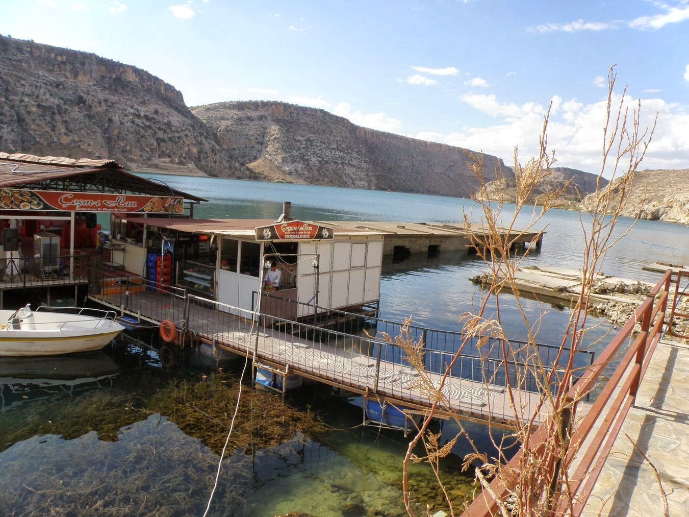
At this point the boat turned around and returned to old Haifeti where we enjoyed a great lunch at a restaurant built over the water.  I think this restaurant was actually built above a roof of one of the submerged buildings.  Immediately next to it was another submerged building and then a partially submerged mosque.  It was like looking at a ghost town -- where most of the town is underwater and the town is dying block-by-block as one goes uphill on the streets.  A few of the higher-level homes were still occupied; all of the lower-level homes and businesses were vacant except for the restaurants next to where the few river boats docked.  Seemed sad.


Tavuk Izgara = grilled chicken
We had ordered lunch before departing on the boat, so lunch was served as soon as we returned.  And what a lunch it was!  Not as elaborate as the first day's lunch at the Iman Çadaş restaurant in Gaziantep, but still a very nice lunch.  Mezze of 4 starters were served; then the main course; followed by plates of fresh assorted melon slices.  Bill and I opted for the tavuk izgara -- grilled spiced chicken chunks.  And it was very good.  The red peppers were different in this region.  We are accustomed to the sweet long red peppers in the area around Fethiye and like those very much.  These peppers looks like very small red bell peppers but they were quite hot.  I liked these but some people found these pepper too hot to eat.  That was a common complaint among our group; a few people found the food in this region too spicy.  I loved it.

After lunch we backtracked southward to the main highway, then eastward to Şanliurfa.   The preface  Şanli in front of a city or town name means 'glorious' or 'divine' and usually means that someone important in religion is from this town or lived in this town or that some significant religious event occurred in this town.  


Castle above Urfa, a/k/a Şanliurfa
This city is ancient.  It has been known as Ur, Urwa and Urfa, as well as Odessa or Adessa or Edessa.  I believe it was called Edessa when the French Crusaders were here very long ago; but for Biblical references I think the more recognized name is Ur.  The Turkish have given this city the preface of Şanli in honor of the battles that happened here with the French; a recognition of the religious significance of those battles.  


The squiggly beneath the 'S' means it is an 'sh' sound.  Therefore, the correct pronunciation of this city today is SHAHN-lee-UR-fah.


Tony sitting on one of the many lobby sofas
Our hotel was in the old town district, directly beneath the ancient castle.  We would again visit this area later in the trip so I will wait for another blog posting to describe Şanliurfa.  The hotel was posh Turkish sultan style decor.  This was much appreciated after the lower-quality hotel in Gazientep.   In Gazientep the price of real estate for an apartment 3 years ago was 10 lira per square meter.  That was before the Syrian refugees arrived en masse.  Because of the sudden influx of population, those same apartments now cost 1,000 lira per square meter.  Supply and demand; always, supply and demand.  Due to the high price of real estate now in Gazientep, our hotel was of lesser quality than normally provided on these tour trips.  It was okay but barely okay.  This hotel in Şanliurfa was top notch.


The ultra-dropped crotch in pants is popular here with
both men and women.  Sometimes the women's pants
have the crotch all the way down at their ankles.
We walked the old city district for sightseeing.  It was filled with all the typical Turkish bazaar type goods; nothing we wanted or needed.  We were on a mission to find Nescafe instant coffee so we could have coffee when the rest of our group enjoyed tea several times daily; but while Nescafe is found everywhere in Marmaris and Fethiye, it was not to be found here.  Bill finally did find some of the tiny packets of Nescafe 3-in-1 in a shop down a narrow alley, and we bought a few so we could enjoy coffee in our hotel room.  I prefer black coffee but creamer and sugar will do.

We soon tired of walking around the old city.  I saw several men who appeared to be wounded Syrian refugees.  Some had severe leg damage; one had both arms blown off at the elbows; and some wore bandages on faces and heads.  We were not that close to Syria but this is a large city and apparently lots of Syrians have sought refuge here. 

We did notice a much larger Arabic influence here than anywhere else we have visited in Turkey.  The people were not as open and friendly as the Turks we have met elsewhere.  They seemed to have a harder life here.

  
Every cloud has a silver lining.
Photo taken from our hotel window.
A good way to end the day.

Friday, November 1, 2013

Tour Second Day: Yesemek Open Air Museum; Islahiye; Zeugma Museum


Carvings are found sitting all up the hillside at Yesemek Open Air Museum.
These are ancient and have withstood the ravages of the elements well.
After a leisurely breakfast and a fairly late start on the day our group departed the hotel in Gaziantep at 09:00 for Day 2 of our tour.  This day we had a new driver and a really nice Mercedes small bus.  It had less luggage room than the bus yesterday but had much more leg room and very comfortable seats.  Our driver did not speak any English but he always had a smile for everyone and had a great personality.  He invited us to visit his village and share a drink of ayran provided by his wife.  We all thought that would be a nice thing to do, so he drove first to his village.  
As always, click on any image for larger view.

Bus driver and his youngest son


We westerners were quite the novelty in that little village!  Women were looking down at us from their second-story windows and soon were holding their babies and toddlers out the windows for us to photograph.  We could smell the goats of the village but I don't remember seeing any of them walking about.


Bus driver's wife serving us ayran.
The driver's wife served glasses of ayran to everyone.  It is considered very rude in Turkey to refuse something offered to you.  But both Bill and I did refuse anyway, as neither of us can stand ayran.  I think it is positively vile!!!  I would gag involuntarily if I attempted to be polite and drink that salty tangy liquid.  That would be even more rude than simply saying "no, thank you."  I think everyone else in our group liked ayran, or they at least drank that one glass of the stuff. Most of them really did like the stuff and drank it several times during this trip.  Ayran is like the national drink of Turkey. 


Village women showing us their babies.  Hold on
tight!  That is an upstairs window.
Here is a recipe; you be the judge as to whether this is something you might like to drink:        How to make ayran

The driver very much wanted us to visit the new Gaziantep zoo.  He was quite proud of it.  Our group declined; we have all seen very nice zoos in many cities; this trip was to experience ancient sites.  

The first scheduled tour stop was a drive of several hours -- almost on the border with Syria! There have been no 'incidents' at the Syrian/Turkish border in recent weeks and we were not near any of the re-settlement camps so we honestly were not concerned with any safety issues. 


Syria as seen from my bus window
The drive took us along a good distance within 2.5 miles of the border.  What do you know! That part of Syria did not look a bit different than that part of Turkey.  Hard to tell exactly where that official border is.  We had discussed this with our guide yesterday.  This part of Turkey has a long history with its neighbors.  The population of this region of Turkey is roughly 1/3 Turkish; 1/3 Arabic descent (which includes Syrians); and 1/3 Kurdish; with a nominal number of Syriac Orthodox Christians.  


Syria viewed from my bus window
All of them get along just fine.  They have lived together for more than 2,000 years and there are family relations across all the borders of Turkey/Syria and Turkey/Iraq and Turkey/Iran.  The countries might have borders but the family relations do not.  The Turks will not abandon their Syrian relatives and friends during this time of crisis in Syria.  There are now officially more than 600,000 Syrian refugees in Turkey; locals estimate the actual number to be about one million.  Turkish Prime Minister Erdogan wants to give these Syrian refugees the right to vote in Turkey.  Hmmmmm.........wonder who they might vote for in the next election.  And their Turkish relatives and friends would probably vote for the same person -- the one who allowed the Syrians to enter Turkey and is assisting with housing and granting voting rights even through they are not citizens of this country.  What a way to guarantee an election!


Picking cotton in fields near Yesemek.  There were
many, many cotton fields.  Had no idea so much
cotton was grown in this part of the world.


Anyway......politics aside......we were on holiday so we forgot about the Syrian troubles and focused on our day.  Our destination was the Yesemek Open Air Museum -- the oldest discovered sculpture workshop in the world, dating back to the second millennia B.C.  Turkey has opened several Open Air Museums around the country.  This is the first one we have visited. 


Lady selling brochures for the museum.  She is wearing
the colorful typical Turkish clothing.  
Back to the topic at hand--our visit to Yesemek Open Air Museum.  According to the brochure purchased at the museum, the Yesemek quarry and sculpture workshop was first discovered in 1890 by Felix von Luschan, director of the Zincirli, ancient Sam'al excavations.  The sculpture workshop provided study of Hittite and Neo-Hittite art and sculpture.  It shows methods of quarrying and shaping basalt blocks.  It provides examples in every stage of production of rough-outs of sphinxes, lions, relieves, statues in the round, etc.  It provides stone rough-outs of motifs of many things, including those lions, sphinxes, mountain gods and man-bears.  This work shows the cross-cultural exchange of symbols that are present in sculptural art.


A sphynx weighing several tons.  How did they move
these heavy stones all up this hillside?


The first craftsman were probably of Aramaean origin in the Neo-Hittite period of 10th to 8th centuries B.C. when the region was within the Kingdom of Sam'al.  Later the Hittites worked here.  None of the tools used in making the sculptures have been found.  Analysis of samples from various stages of the sculptures indicate that tools used likely included stone hammers and chisels, polishing stones and levers. 


Note the detail of this face and headdress
and think of how old it is.  These are well
preserved to have been exposed  so long.

No evidence of the saw or drill has been recovered in Yesemek; nevertheless basalt orthostates with drilled holes found 6 miles north of the workshop in excavation levels dating to 18th and 17th centuries B.C. suggest that the drill was known to the stone masons at Yesemek.  Architectural sculptures commissioned from Yesemek were sent to their final destination unfinished and did not have holes drilled into them.


A tiny piece of old art.
The Yesemek quarry and sculpture workshop was abandoned in the last quarter of the 8th century B.C.  The partially-carved and some fully-carved stones are placed all the way up the hill. 


Two people.


Some of the workmanship is astonishing considering the tools that must have been available at the time.


Detail still visible.  Man with upraised arms.


Next we drove to the nearby town of Islahiye for lunch.  Prior to the current Syrian rebel uprising, this town was the railway connection for the train direct to Damascus, Syria.  That train route has been discontinued due to the civil war in Syria.  
One of the many cups of tea daily.
This is how Turkish tea is served.


Small town of Islahiye where we westerners were a surprise.
You should have seen the stares we got from the local people!!  They do not get tourists here; we were very much oddities!  A local girl overheard Tas speaking with us so she could tell he was our guide.  She asked him in Turkish, "Why are they here?"  Tas got a laugh out of that.  There are no historical sites in Islahiye, so why were we there.  Just to eat a local lunch.  Which turned out to be the least expensive meal of our entire trip and just as good as any of the more expensive city places where we later dined.


I noted later on our map of Turkey that when at Islahiye we were only about 70 miles from the first Christian church in the world.  The very first Christian church.  Supposedly founded in 32 A.D. by the Syriac Orthodox Christians.  It is located at Hatay, Turkey, a/k/a Antakya; and in ancient times was known as Antioch.  But it is not possible to see everything and this group tour did not go down to Antioch/Hatay/Antakya.  Very sorry we missed this. Especially regrettable since later in the tour we would be visiting several Syriac Orthodox sites.  More basic information can be found here:  http://en.wikipedia.org/wiki/Antioch

Portion of a 2nd century floor mosaic
Rather than continuing south to Antioch, we continued north to the highway connecting eastward back towards Gaziantep, about a 2 hour drive.  Next destination was the fabulous Zeugma Museum.  I cannot praise this museum too highly; it is great.  The full name is something like the Gaziantep Archeological Museum but it is known as the Zeugma Museum.  Here are housed some of the artifacts and spectacular mosaics which were rescued from the very important ancient Roman city of Zeugma.  The site of Zeugma was flooded after the building of the Birecik Dam on the Euphrates River in year 2000.
2nd century floor mosaic covering an entire room


Most of the mosaics dated to 2nd century A.D.  These are just unbelievable.  Such precision craftsmanship!  As well as artistry.  Most of the mosaics were enormous sections of floor designs.  Some were from pools but most were from regular floors.  Those ancient rich Romans did enjoy elegant homes of that period.  Photography is allowed inside the museum but only without flash lighting.  So my resulting non-flash photos most definitely do not do justice to these beautiful mosaics.


Small section of a floor mosaic.  Taken
with zoom lens but no flash


A large wall mosaic.


Here is link to a bit of information on this museum:

Zeugma Museum

And here is a link to a YouTube video of some of the mosaics in this museum:

YouTube Video of Zeugma Museum

Latrine on left. Floor pools flow toward the latrine; then
waste was removed by the water down the pipes and out
of the building.  What a convenience to have indoor toilets.


The photo on left was taken from 2 stories above, looking down on floors of several adjoining rooms which were removed from the ancient town of Zeugma and reconstructed here in this museum.  This reconstructed exhibit was approximately 80-feet long by 20-feet wide.


Probably the most famous mosaic housed here is the one of the Gypsy Girl.  The Gypsy Girl is mounted on a wall inside a darkened room accessed via a series of turns from the well-lighted interior of the museum, resulting in almost no ambient light in the room at all.  The eyes do appear to follow you as you move about the room.  How the artist achieved this using small squares of stone is amazing.  And with only those tools available back in those ancient times makes it even more amazing.  Bill and I were reminded of our friend Randal on M/V Dora Mac.  Randal got very interested in mosaics in Cyprus, Turkey and Tunisia.  He would have especially appreciated this Gypsy Girl.

The Gypsy Girl was found beneath layers of soil in the House of Menad.  Historical artifact traffickers had raided this building of all other mosaics, but they did not find the Gypsy Girl during their illegal diggings because she was covered with soil.  She was later found during the proper archaeological excavations performed before the dam flooded Zeugma.  As a joke, the excavation workers dubbed this mosaic The Gypsy Girl because of her uncombed hair, round face and earrings.  That name stuck.  There is no illuminating data regarding her identity but some scholars claim she is one of the maenads present in Dionysus festivals because of the tendrils near her head.  (In Greek mythology, maenads were the female followers of Dionysus, and the most significant members of the Thiasus, the god's retinue. Their name literally translates as "raving ones")  Others speculate that she might be a portrait of Alexander the Great.  Frankly, I don't buy that idea.  The appearance of both sadness and joy in the facial expression illustrate the stage artists had reached in portraits composed by tiny mosaic colored tiles.
The Gypsy Girl.
Remember, no flash was allowed or there would be a better photo.
The museum building on the right-hand side houses mosaics from the 5th century A.D.  These are very different from those mosaics crafted 300 years earlier.  And the differences were dramatic.  Very dramatic even to our unlearned eyes.  

The mosaics from 2nd century were precision cut and mounted; colors were vibrant even after all these years; designs were extremely intricate.  

The mosaics from the 5th century were not precision cut and mounted; the tiles were not nearly as tiny as those produced earlier and the edges appeared roughly cut.  The designs were not intricate and exhibiting artistry.  The designs of the 5th century appeared crude in comparison. Plus, the 5th century mosaics were just plain beige background spaces with crudely designed animals, birds and leaves in basic brown and black tiles.  No colors; no artistry; poor craftsmanship.  
The best wall mosaic in the building housing 5th century work
What happened during that 300 year period to destroy man's ability to produce this artwork?

This is pure speculation but it might have something to do with the Christian belief at that time that it was sacrilegious to depict a human being in a painting or sculpture or mosaic.  That period could feasibly have resulted in a loss of artists' ability to create beautiful works as they had been able to accomplish 300 years earlier.   That is the only logical explanation that occurs to me.  Religion told them not to do it and over time they lost the knowledge and ability to do it.

Whatever the reason, the decline in quality of craftsmanship and artistry is remarkable.